Friday, July 11, 2025

Garnet & Coloma

While making our way from Missoula to Seeley Lake, we decided to make a side trip to Garnet - Montana's best preserved ghost town.  Garnet, founded around 1895, is about eleven miles off Montana Route 200 (nine of which are on a well-maintained dirt road).  The town was primarily a hard rock gold mining town, but its boom was short-lived, mostly ending by 1900.  At its peak, Garnet had thirteen saloons, a grocery store, a barber shop, a mercantile store, and three hotels.  It is amazing that many of these structures are still standing today.

About seven miles along the road leading to Garnet you will come to the Sand Park Cemetery . . .
Make sure to take a few minutes to visit the graves of miners who worked primarily in Coloma 
(Coloma is another ghost town in the area . . . the bottom of this post has pictures of what remains of the town)

We found it interesting how people have paid homage to these miners . . .
It appears that the coins are a form of tribute to the miners, much like graves of fallen soldiers 

Shortly after leaving the cemetery watch for this old ranger cabin . . .
It was used to house the ranger who was on patrol for forest fires . . .
Today, it is used as a warming shelter for snowmobilers

Here's a view of what you will find inside the cabin

Soon after leaving the ranger cabin you will come to the ghost town of Garnet

Pictured above is one of the remaining hotels . . . Notice the pole sticking out above the second floor opening . . .
It used to have a pulley on it to hoist guests steamer trunks to their second floor rooms . . .
Miners rented cubicles and slept on the floor of the third story

Can I offer any of you a drink?  You look mighty thirsty!

This is Davey's Mercantile Store . . . it operated from 1898 to 1948
It was one of the town's first stores, and its closure, along with the death of owner Frank Davey,
marked the beginning of Garnet's decline into a ghost town

We found this display very interesting . . .
Each of the items had a card in front of it asking you, "What is it"?
To know the answer you turned the card over . . .
What do you think the item on the left was used for? It was a baby walker!

Even some of the original wallpaper remains . . . several of the walls were lined with old newspapers

Looking inside one of the guest rooms in the hotel

Kent wandering around the remains of the miners cabins

Ever seen a three seater before?  There was even a four seater outside the hotel!
Makes you wonder what kind of conversations went on while they took care of business!

This placard, outside one of the cabins, was rather interesting . . .
The owners allowed newlywed couples to live in it rent free for one year or until the next couple in town got married

A picture of Main Street

No, not ghosts from the past (at least not yet) . . . just us!

After visiting Garnet, and on our return trip to the highway, we saw a sign directing us to Coloma . . .
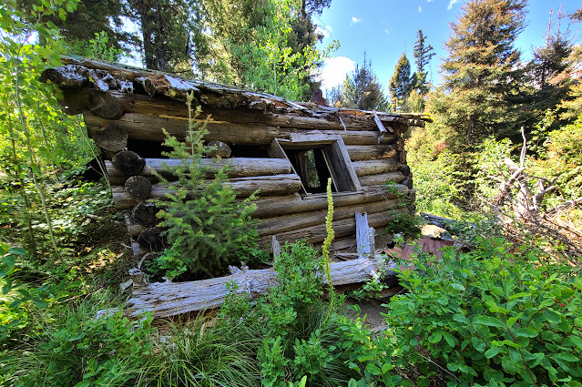
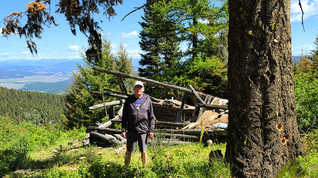
While there are several structures in the area, most are in a dilapidated state

Probably the best thing Coloma has going for it are the views

It looks like Coloma has a different kind of ghost living there today

Here's a picture from a scenic viewpoint along the way . . . 
This is looking north towards Route 200 (in the valley) and Seeley Lake (nearer the mountain range) . . .
As you can see, Garnet sits up on top of the Garnet Mountains . . . thus it's name

Bumblebees feeding on a flowering thistle


If you choose to go to Garnet (and we hope you do), allow yourself three to four hours for the drive, exploration of the town, and a side trip to Coloma.  We used this as our morning outing for our journey from Missoula to Seeley Lake.  There is a $10/person fee to visit Garnet and can be paid at a self service kiosk in the parking area.  These monies are used to preserve Garnet and keep it from becoming a ghost town like Coloma.


Thursday, July 10, 2025

Hiawatha Bike Trail

Allison has always dreamed of riding the Hiawatha Bike Trail.  In fact, it has been on her bucket list since 2012 when she first saw it featured in a travel magazine.  The trail’s namesake is taken from the Hiawatha luxury passenger train that once traveled the same route through the Bitterroot Mountains, on the Idaho-Montana border, up until 1961.  It opened to the public in 1998 as a rail trail and features fifteen miles of graded trail (that is mostly downhill), with ten tunnels (the longest being 1.7 miles) and seven high trestles (highest is 284 ft).  It certainly lived up to its hype and gave us an amazing adventure!

The Hiawatha Bike Trail starts near Mullen, Idaho which is about an hour east of Couer d'Alene . . .
This was our view of Couer d'Alene Lake as we left town on our way to the Trail

After an easy check-in process, we picked up our bikes, helmets and lights . . . we are ready to go!

Our first challenge is to make it through this 1.7 mile long tunnel . . .
There are no lights, it's dripping water, muddy and pretty chilly . . . other than that it wasn't too bad!

This gives you a good idea of what it looked like inside the tunnel . . .
Now, imagine it pitch black with only a bike lamp and a headlamp to light your way!

Once you come out the other side, you are greeted by this waterfall . . . 
Make's one wonder if this didn't have something to do with the tunnel's dripping??


There are several trailheads where you can start the Hiawatha, if riding through the tunnel makes you nervous

We were warned not to ride too fast or we would "rooster tail" mud on our backsides . . .
It made us smile when we saw this young lad, from New Zealand, and his speckling of mud . . .
Seems he didn't have much of a choice riding behind and attached to his father

One of our first trestle views . . .
We will be riding over this one in a couple of hours

Here's a more typical tunnel along the way . . .
In general, once through the "big guy", you could see "light at the end of the tunnel" on most of the others

Every half mile or so there are point of interest signs that were fun to stop and read
(Click on this picture and it may enlarge it enough to read . . . if you're curious about what it says)

This picture gives a good feel of what it felt like riding through the Bitterroots . . .
And the excitement that lays ahead as your next trestle crossing comes into view

One of the many trestle crossings

Another tunnel

This placard explained that most of the trestles were originally constructed of wood . . .
Most of these burnt down from sparks thrown from the train and it wasn't long until they were rebuilt with steel

Here's a good view of a typical trestle you will cross on your adventure . . .
Make sure to stop and take time to look over the railing . . . you're a long ways up there!

Kent exiting yet another tunnel

We found the trestles every bit as interesting as the tunnels . . .
Can you imagine the work (and craftsmanship) that went into building all these tunnels and trestles?

The last tunnel before coming to the "end of the line!"
(The last time this tunnel was used by a freight train was 1980 . . . the last passenger train was 1961)

We paid to have our bikes and ourselves transported back to the trailhead . . .
Many people choose to turn around and ride back uphill to make the journey last a little longer . . .

Guess where they drop you off?  That's right, at the big tunnel!
You have to ride 8,771 ft back through the mountain to return your bike and bike lamp . . .
In this picture you might notice a light in the back of the tunnel . . . 
It's not light coming from the other end, but someone riding towards us!

We had a great day riding the Trail of the Hiawatha!  We're glad Allison kept this adventure on her bucket list for thirteen years . . . it certainly was one we wouldn't have wanted to miss.  Don't let the fifteen miles of biking intimidate you . . . it's all downhill!  Just take some time to stretch, enjoy the views, and read a few informational placards.  Our leisurely pace took us about four hours to complete the ride.


Wednesday, July 9, 2025

Montana Misc.

We're putting together a post featuring a collection of photos from our week in Montana!  These are some of the simpler moments that made our trip memorable, even if they don't quite warrant their own individual posts.  Hope you enjoy seeing them!

If you're in Seeley Lake and want a good burger and shake at a reasonable price, don't pass up "The Ice Cream Place" . . . it's right in the heart of town . . . and will be the one with people lined up at their outside counter!
(Another contender was Casa Caro:  Great Mexican food, reasonable prices and excellent service)

Sure tasted good after a hot hike to Morrell Falls
(Maybe we should become food bloggers!)

We stayed at the Double Arrow Lodge for our entire stay in Seeley Lake . . .
What a great choice:  Nice people, they serve a fine breakfast, rooms were quaint and quiet

Here was the cabin we stayed in . . .
It's actually a quad, with four separate rooms on each corner . . .
We had it all to ourselves, until the last night when another couple took a room on the back side

We enjoyed reading, on the porch, as we watched the summer sun set through the ponderosa forest

Oh, did we mention the deer?
  Every evening and morning we were greeted by whitetail deer

One evening we took a short drive, west of Seeley Lake, to an old lookout that has been remodeled . . .
It sits on a small hill (4,948 ft) and provides great views of the surrounding area
  
It was built in 1933 and used by the Forest Service until the mid-1980's . . .
Today it can be reserved and used for overnight accommodations (it does have electricity)
4948 ft elevation

There weren't any benchmarks at the Double Arrow Lookout,
but we did find this Forest Service survey marker from 1970

An example of the views from the top . . .
We are looking south towards Placid Lake State Park

When in Seeley Lake, don't miss visiting "Gus" the world's largest larch tree
(Click on the picture and it will open a larger photo)

Here's Kent getting his picture taken with Gus

Fireweed blooms from the bottom of the stalk upwards, and as summer progresses,
 the blooms gradually move towards the top. It looks like we are about halfway through summer!

As we were crossing the Continental Divide, at McDonald Pass, and heading for Helena, we stopped at a view point and pulled up our NGS map to see if there might be a benchmark in the area . . .
Sure enough there was and it's supposed to be in the vicinity of this tower!


While it doesn't have a date stamped on it, NGS shows it was placed here in 1958

After hiking Red Mountain, near Rimini, Montana, Kent stopped the car so he could remove the
batteries from his GPS and charge them as we traveled to Missoula . . . 
What he couldn't figure out was the sign that can be seen behind him??
There were no buildings or driveways around . . . just a wide paved spot off the side of road . . .
I guess we better get moving!

Forget-Me-Nots and Buttercups along the South Fork of the Coeur d'Alene River

This frog was hiding in the flowers along the creek, it startled Allison as she was taking a picture . . .
 it jumped into the river and she jumped back!

If you made it this far into the post, you are to be commended, and must be a dedicated follower of our blog, Beyond My Couch.  We know these pictures might not have been the most exciting, but they were important for us to include.  They helped us fill in some memories that might have otherwise been overlooked while we were working on other posts.   Thanks for following along on our adventures!